
A single strike on an underground utility line can transform a routine construction project into a nightmare. The backhoe operator hits something unexpected, and suddenly you’re dealing with a ruptured gas main, a neighborhood without power, and a project timeline that just extended by weeks. These incidents happen thousands of times each year across North America, costing the construction industry billions in damages, delays, and liability claims.
Subsurface utility engineering exists precisely to prevent these scenarios. SUE represents a systematic approach to identifying, locating, and mapping underground utilities before anyone breaks ground. The process goes far beyond the traditional “call before you dig” approach, providing engineering-grade data about what lies beneath the surface. For project managers, engineers, and contractors who’ve experienced the chaos of an unexpected utility strike, the value of comprehensive underground mapping becomes immediately apparent.
What makes SUE particularly critical is the invisible complexity beneath modern construction sites. Urban areas contain dense networks of water mains, sewer lines, telecommunications cables, electrical conduits, gas pipelines, and fiber optic networks, often installed over decades with varying levels of documentation accuracy. Some utilities were installed before GPS existed. Others were mapped using methods that placed them within 10 feet of their actual location, which might as well be a mile when your excavator is operating inches from a high-pressure gas line.
The Fundamentals of Subsurface Utility Engineering
Understanding SUE requires grasping both its technical foundations and the standardized framework that governs how professionals approach underground utility investigation. This isn’t guesswork or estimation. It’s a rigorous engineering discipline with established protocols.
Defining SUE and ASCE 38 Standards
The American Society of Civil Engineers established Standard 38 specifically to create a common language and methodology for subsurface utility investigations. Before ASCE 38, different contractors and engineers used varying approaches, making it difficult to compare results or establish consistent quality expectations. The standard changed that by defining exactly what constitutes adequate utility investigation at different levels of certainty.
ASCE 38 establishes a framework where utility data quality is categorized into four distinct levels, each with specific requirements for how information is gathered and verified. This standardization means that when an engineer specifies “Quality Level B” investigation, everyone involved understands exactly what that entails. The standard also assigns professional liability appropriately, clarifying who bears responsibility when utility conflicts arise despite investigation efforts.
The Four Quality Levels: From Records to Test Holes
Quality Level D represents the starting point: existing records. This includes utility company maps, as-built drawings, and permit records. While useful for initial planning, this data often contains significant inaccuracies. Utilities may have been relocated, records might be incomplete, or original installations may have deviated from planned routes.
Quality Level C applies surface-visible features like valve covers, manholes, and meter boxes to supplement record data. This provides better horizontal positioning but still lacks vertical depth information.
Quality Level B employs geophysical methods to actively locate utilities. Ground penetrating radar, electromagnetic locating, and other technologies detect buried infrastructure and provide horizontal positioning typically accurate within one foot. This level represents the most common standard for design-phase investigations.
Quality Level A delivers the highest certainty through physical exposure. Test holes, often created using vacuum excavation, directly reveal utility locations with precise horizontal and vertical measurements. This level is reserved for critical conflict areas where design decisions require exact positioning data.
Mitigating Financial and Operational Risks
The business case for comprehensive utility investigation becomes clear when you examine the actual costs of underground strikes and the cascading effects they create throughout project execution.
Reducing Costly Utility Strikes and Repairs
Utility strike costs extend far beyond the immediate repair expense. A damaged fiber optic cable might cost $50,000 to repair, but the telecommunications company’s business interruption claim could reach into the millions. Gas line strikes trigger mandatory evacuations, emergency response costs, and potential regulatory penalties. Water main breaks flood excavations, damage adjacent structures, and require extensive dewatering before work can resume.
Insurance claims data reveals that the average utility strike costs between $50,000 and $100,000 when all direct and indirect expenses are tallied. Major incidents involving gas or high-voltage electrical lines frequently exceed $500,000. These figures don’t account for the reputational damage contractors suffer when their projects make local news for disrupting essential services.
The cost of comprehensive SUE investigation typically runs between 0.5% and 2% of total project construction costs. When compared against even a single moderate utility strike, the return on investment becomes obvious. Projects that invest in thorough subsurface investigation routinely report zero utility strikes, while those relying solely on utility locate services experience strike rates between 10% and 30%.
Avoiding Project Delays and Change Orders
Unexpected utilities discovered during construction trigger immediate work stoppages while engineers redesign around the conflict. These delays cascade through project schedules, affecting subsequent trades and potentially pushing completion dates into unfavorable weather conditions or beyond contractual deadlines.
Change orders resulting from utility conflicts average 15% to 20% of original contract values on projects where inadequate investigation was performed. The redesign process itself consumes engineering hours, requires utility company coordination, and may necessitate permit modifications. Meanwhile, equipment sits idle, crews are reassigned or laid off, and overhead costs accumulate without productive work occurring.
Projects with Quality Level B or A utility data experience dramatically fewer change orders. When conflicts are identified during design, solutions can be incorporated into bid documents, eliminating the cost premium associated with mid-construction modifications.
Enhancing On-Site Safety and Public Welfare
Beyond financial considerations, subsurface utility engineering directly protects human lives and maintains essential services that communities depend upon daily.
Protecting Workers from Hazardous Utility Breaches
Natural gas line strikes create explosion and asphyxiation hazards that can prove fatal within seconds. High-voltage electrical contact kills workers instantly. Even low-pressure water lines can create trench collapses when saturated soil loses structural integrity. These aren’t theoretical risks: construction industry fatality statistics include workers killed by utility strikes every year.
Accurate utility mapping allows contractors to implement appropriate protective measures before excavation begins. When crews know a high-pressure gas main runs within feet of their work area, they can hand-dig the final approach, use air knives instead of mechanical excavation, or install temporary protective barriers. This knowledge transforms potentially fatal situations into manageable construction challenges.
OSHA regulations require employers to identify and mark underground utilities before excavation. While calling 811 satisfies minimum legal requirements, the one-call system’s accuracy limitations mean workers may still encounter unexpected hazards. SUE investigation provides the additional certainty needed to genuinely protect crew safety.
Ensuring Community Service Continuity
Utility strikes affect far more people than those directly involved in construction. A severed telecommunications line might disable 911 service for an entire neighborhood. Water main breaks leave hospitals, schools, and vulnerable residents without service during repairs. Electrical outages shut down businesses, spoil refrigerated inventory, and disable medical equipment that homebound patients depend upon.
Construction projects that damage essential services face intense public scrutiny and political pressure. Local officials receive constituent complaints. Media coverage portrays contractors negatively. Future project approvals become more difficult to obtain. The community relations damage from a single high-profile utility strike can affect a contractor’s business development efforts for years.
Advanced Technologies Powering Modern SUE
The effectiveness of subsurface utility engineering depends heavily on the sophisticated detection technologies that have evolved over recent decades. Modern SUE practitioners deploy multiple complementary methods to build comprehensive underground pictures.
Ground Penetrating Radar and Electromagnetic Locating
Ground penetrating radar transmits electromagnetic pulses into the ground and records reflections from buried objects. The technology works particularly well for locating non-metallic utilities like concrete sewer pipes, clay drainage tiles, and plastic gas lines that electromagnetic methods cannot detect. GPR can identify utilities at depths up to 15 feet in favorable soil conditions, though performance varies significantly based on soil moisture, clay content, and surface conditions.
Electromagnetic locating detects metallic utilities by sensing the electromagnetic fields they generate or by inducing signals onto conductive pipes and cables. Active locating involves connecting a transmitter to a utility and tracing the signal with a receiver. Passive locating detects naturally occurring signals from energized power cables or radio frequency interference on telecommunications lines. The combination of active and passive methods can locate most metallic utilities with horizontal accuracy within inches.
Neither technology works perfectly in all conditions. GPR struggles in clay-heavy soils where signal attenuation limits penetration depth. Electromagnetic methods cannot detect non-metallic utilities unless a tracer wire was installed during original construction. Experienced SUE technicians understand these limitations and select appropriate methods based on site conditions and target utility types.
Vacuum Excavation for Non-Destructive Verification
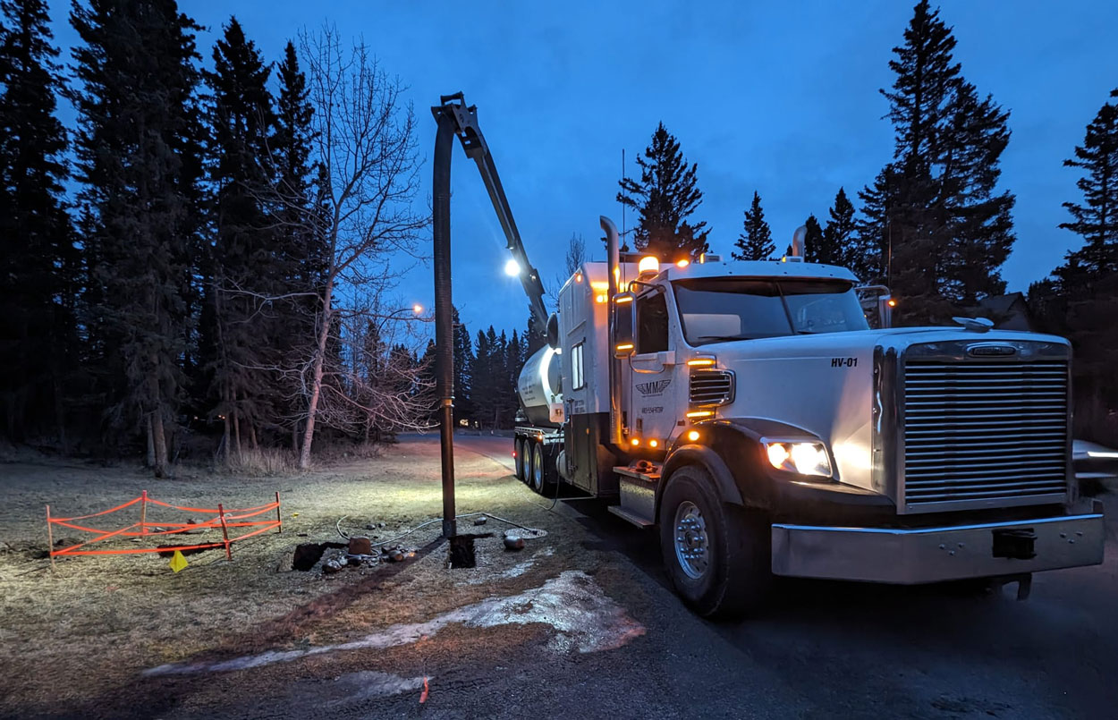
When geophysical methods indicate utility presence but precise positioning is required, vacuum excavation provides non-destructive verification. High-pressure air or water loosens soil while a powerful vacuum removes material, creating a test hole that exposes utilities without risking damage from mechanical excavation.
Vacuum excavation, often called hydrovac or air excavation, has become the standard method for Quality Level A investigation. The technique can create precise exposure holes in minutes, allowing technicians to measure exact horizontal and vertical positions. Unlike traditional hand digging, vacuum excavation works efficiently in compacted soils and can reach depths of 20 feet or more.
The exposed utilities can be visually identified, photographed, and measured with surveying equipment. This direct observation eliminates the interpretation uncertainty inherent in geophysical methods. When project success depends on knowing exactly where a utility runs, vacuum excavation provides definitive answers.
Integrating SUE into the Design and Planning Phase
The greatest value from subsurface utility engineering comes when investigation occurs early enough to influence design decisions. Discovering utility conflicts after construction begins limits options and increases costs dramatically.
Optimizing Utility Coordination and Relocation
Early utility identification allows project teams to coordinate with utility owners during design development. If a proposed storm sewer alignment conflicts with an existing gas main, designers can adjust the route, modify the depth, or initiate relocation discussions before construction documents are finalized. These conversations proceed more productively when everyone works from accurate utility data.
Utility relocations require months of lead time for design, permitting, and construction. Projects that identify relocation needs during preliminary engineering can schedule this work to complete before primary construction begins. Those that discover conflicts during construction face the choice between expensive expedited relocations or extended project delays while normal utility company processes unfold.
Accurate utility data also reveals opportunities to share corridors, reducing excavation requirements and minimizing surface disruption. When designers know exactly where existing utilities run, they can position new installations in available spaces rather than inadvertently creating conflicts that require future resolution.
Building Accurate Digital Twins and BIM Models
Building Information Modeling has transformed construction project delivery, but BIM models are only as accurate as the data they contain. Incorporating SUE data into BIM creates digital twins that reflect actual underground conditions rather than assumed or historical positions.
Three-dimensional utility models allow clash detection during design, identifying conflicts between proposed construction and existing infrastructure before work begins. Engineers can visualize complex utility networks, understand spatial relationships, and develop construction sequences that avoid underground hazards.
These digital models become permanent project records, improving the accuracy of future utility information for subsequent projects in the same area. As more projects incorporate SUE data into digital deliverables, the cumulative improvement in regional utility mapping benefits entire communities.
The Long-Term Value of Accurate Utility Mapping
Investment in subsurface utility engineering pays dividends beyond the immediate project. Accurate utility data becomes a permanent asset that reduces risk and improves efficiency for future work in the same area.
Municipal agencies that require SUE for capital projects gradually build comprehensive utility databases that improve planning accuracy across their entire infrastructure network. Private developers who invest in thorough investigation protect their projects from costly surprises while contributing to better regional utility records.
The construction industry continues moving toward more sophisticated underground investigation as project complexity increases and tolerance for utility strikes decreases. Regulatory requirements are expanding, insurance carriers are demanding better risk management, and project owners are recognizing that prevention costs far less than remediation.
For contractors and project owners planning excavation work, partnering with experienced utility investigation providers makes sound business sense. Companies like Double M Construction Group bring the specialized equipment and expertise needed for comprehensive subsurface investigation, including hydrovac services that enable Quality Level A verification. Learn more about how professional utility investigation can protect your next project from costly underground surprises, contact our team today.